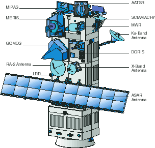
ASAR
(Advanced Synthetic Aperture Radar):
is a C-band SAR which continues the
all-weather microwave imaging capability of the ERS SARs. The figure below
shows imaging configurations for the five different modes of operation. Image
Mode provides up to 100 km swath coverage at 30 m resolution, similar to the
ERS SARs, but the new beam steering capability enables acquisition to take
place in any one of 7 different image swath positions (IS1 to IS7 with
incidence angles 15° - 45°) spanning 500 km, in VV or HH polarisation.
Alternating Polarisation Mode is similar, but will provide simultaneous
dual-polarised images; either both VV & HH polarisation images, or one of
two combinations of plane polarised and cross polarised images (VV&VH or
HH & HV). Wide Swath Mode (150 m resolution) and Global Monitoring Mode
(1000 m resolution) provide images covering a 400 km swath, in either HH or VV
polarisation. Finally, in Wave Mode, imagettes of 5 km by (5 to 10 km)
will be acquired, spaced 100 km along track and alternating between 2 of 7
across track positions, in either VV or HH polarisation. ASAR will be able to
operate continuously in Global Monitoring Mode, or for up to 30 minutes per
orbit in the higher resolution modes (n.b. ERS SAR operates for 12 minutes per
orbit).
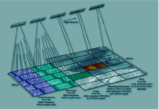
ASAR operating modes
Top
of the page
MERIS
(Medium Resolution Imaging Spectrometer):
operates in the visible and near-infrared in
15 programmable narrow bands at a spatial resolution of either 300 m or 1200
m. With a swath width of 1150 km, MERIS is very well suited to global and
regional monitoring on a 3-day repeat cycle, primarily of ocean colour, but
also of cloud/water vapour, aerosol and vegetation conditions. MERIS provides
well calibrated top-of-atmosphere radiance measurements at high spectral
resolution, plus a range of geophysical products.
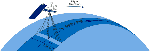
MERIS imaging configuration
Top
of the page
MIPAS
(Michelson Interferometer for Passive Atmospheric
Sounding):
is a Fourier transform spectrometer
measuring emission spectra in the infrared region between 4.15 and 14.6
microns. It is a limb sounding instrument making a series of measurements at
different tangential heights by performing elevation scan sequences through
different sections of the atmosphere with a vertical resolution of 3 km. An
important aspect of MIPAS data collection is that it will provide global
coverage for all seasons, independent of illumination conditions. With its
high spectral resolution and wide spectral range, profiles of atmospheric
pressure, temperature and volume mixing ratios (VMR) of many trace gas species
are obtained. Simultaneous measurements are made across the whole of the
middle infrared part of the spectrum. The azimuth scan geometry of MIPAS in
the anti-flight direction has the principal objective of providing complete
global coverage. In addition, MIPAS will also be capable of scanning
perpendicularly to the flight track so that data can be acquired of volcano
eruptions and trace gas concentrations above major air corridors and across
the dawn/dusk boundary.
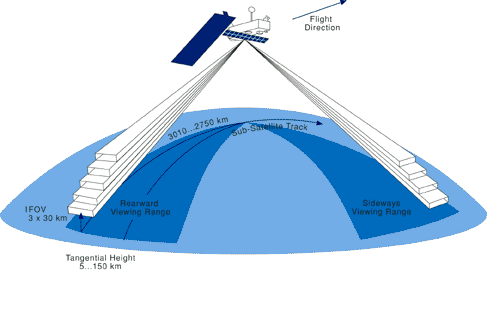
MIPAS limb sounding of the atmosphere
Top
of the page
GOMOS
(Global Ozone Monitoring by Occultation of Stars):
is a UV-visible and near-infrared
spectrometer which measures star light as seen through the atmosphere. GOMOS
is a novel instrument measuring ozone and other trace gases in the altitude
range between 20 km and 100 km, with a vertical resolution of 1.7 km. The
occultation technique is very stable and inherently self-calibrating. This is
due to the fact that the integrated quantity of trace gases along the line of
sight is obtained from the ratio of two measurements taken by the same
instrument within a short time interval. Therefore, even if the instrument
characteristics change slowly over time, the ratios will still produce valid
results. This long term reliability is highly relevant in the context of long
term studies of ozone variability. Daytime occultations are planned in order
to determine diurnal variations in the concentration of gas species, but the
instrument performs best at night. The two high speed photometers are able to
gather information on the scintillation of starlight and thereby provide
information on the fine structure of the atmospheric vertical temperature
profile and transport processes.
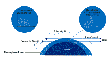
GOMOS stellar occultation
Top
of the page
SCIAMACHY
(Scanning Imaging Absorption Spectrometer for Atmospheric
Chartography):
is an eight channel UV/visible, near to
middle infrared, spectrometer which measures atmospheric trace gas and aerosol
concentrations by observation of reflected and scattered sunlight (n.b. also
by transmitted light when the sun or moon are viewed directly through the
atmosphere). SCIAMACHY is essentially a more capable version of GOME. It views
in either nadir or limb mode within a 1000 km swath providing total column
measurements and atmospheric profiles up to 100 km, at 3 km vertical
resolution. Global coverage will be completed every 3 days at the equator.
Most measurements are achieved by alternating limb measurements with nadir
measurements, providing the opportunity to observe the same volume of air
under different viewing geometries within a short period of time. In limb
mode, SCIAMACHY records atmospheric spectra corresponding to a part of the
atmosphere about 3290 km ahead of the satellite. Soon after (i.e. within
approximately 435 seconds) nadir measurements are made of the same part of the
atmosphere. This data acquisition strategy enables both total column and
profile measurements of trace gas species and aerosol contents to be obtained
to a high degree of accuracy.
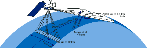
SCIAMACHY limb/nadir operating mode
Top
of the page
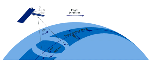
RA-2
(Radar Altimeter):
is an enhanced version of the ERS altimeter
which measures the power level and return time of radar frequency echoes from
the Earths surface (Figure 1.8). RA-2 provides weekly global measurements of
ocean surface topography (and hence circulation), wave height and wind speed.
RA-2 will also provide improved mapping of ice-cap margins and sea-ice as well
as land elevation and lake level. Enhancements to the ERS altimeters include
the addition of an S-Band channel (to enable correction of errors introduced
by ionospheric fluctuations) and a tracking system which automatically keeps
the radar echoes within the sampling window for any surface, to overcome the
problem of lost data at the important ice-cap/sea-ice boundary.
RA-2 operating configuration
Top
of the page
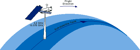
MWR
(Microwave Radiometer):
is a K-band passive radiometer which measures the total
atmospheric water vapour and cloud liquid water content within a cone having a
20 km diameter footprint. The main purpose of the MWR is to provide
atmospheric correction for RA-2 timings. To achieve this the contribution of
the Earths surface is eliminated by taking differential measurements at two
frequencies. The MWR can also be applied to low resolution measurements of
surface emissivity and soil moisture, as well as supporting energy budget and
ice characterisation research.
MWR operation
Top
of the page
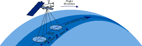
AATSR
(Advanced Along-Track Scanning Radiometer):
provides continuity with the ATSR
instruments on ERS, ensuring the production of a near-continuous 10-year data
set of sea surface temperature at an accuracy level of 0.3 K or better. AATSR
will have the four well established mid/thermal infrared channels, together
with three visible/NIR channels. The two-angle viewing method already
established with ATSR will be used to achieve accurate atmospheric
corrections. Spatial resolution is 1 km at nadir in a 500 km swath.
AATSR operating configuration
Top
of the page
DORIS
(Doppler Orbitography and Radio Positioning Integrated by
Satellite):
is an orbit determination system which
allows the position of Envisat to be fixed to within 5 cm. On-board
measurements are available in real-time to better than 25 m accuracy, but the
very precise measurements are only possible after a time lag of 3 weeks. The
precise orbit data are an essential input to most RA-2 applications and can
also be used (with ground beacons) for monitoring ground movements (e.g.
deformation of the Earths crust). DORIS also enables the estimation of the
total number of free electrons in the ionosphere.
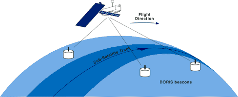
DORIS operating configuration
Top
of the page
LRR
(Laser Retro-Reflector):
will be mounted on a pillar attached to the
nadir panel close to the RA-2 antenna to support-to-satellite ranging
and for RA-2 altitude calibration. The LRR is a passive device which
will be used as a reflector by ground-based SLR stations using high-power
pulsed lasers.
The operating principle is to measure on ground the time of
a round trip of laser pulses reflected from an array of corner cubes mounted
on the Earth-facing side of the satellite. The corner cubes ensure that the
laser beam is reflected back parallel to the incident beam.
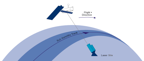
LRR operating configuration
Top
of the page